
 I travel the county quite a bit, meeting and talking with people. Since my conversation is varied, I naturally receive all kinds of responses. One day, a man who is a bit of a recluse drew my attention to an artifact at the edge of the property.
He told me that if anyone was to dig it up, including himself, he would get into trouble with the Federal Government! Naturally, I was intrigued. What was this artifact?
The Unobtrusive Artifact
The man pointed to a small concrete-filled pipe, rusted on the outside, that stuck up from the ground only a very little distance. In the middle of the smoothed concrete top was a little disk, imprinted with words in a circular fashion, much like a large coin. The words read:
U.S. COAST & GEODETIC SURVEY BENCHMARK
ELEV. _____ FEET ABOVE MEAN SEA LEVEL
$250 FINE OR IMPRISONMENT FOR DISTURBING THIS MARK
X149 / 1935
Who knows what the fine would have been today? But what is this, and doubtless other, benchmark(s) all about?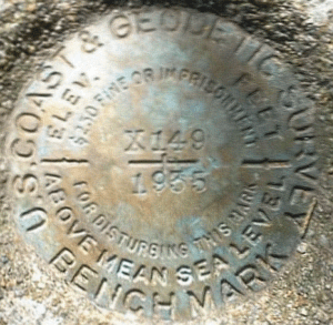
U.S. Coast and Geodetic Survey Benchmark
Benchmarks, such as the one I’d found, are connected with geological surveying; the United States needed surveying to be accurately mapped. As a whole, such bookmarks constitute a National Spatial Reference System (NSRS).
Rather than explain by written word what this is all about, you may enjoy watching this most informative 4-1/2 minute NOAA video…
Did You Notice?
You may have noticed that, as technology improved, new North American Datums (NAD) were enacted. The years in which these occurred were 1927 and 1983.
For the year 1935, NOAA informs us the following advances to the 1927 NAD were made:
- 1934-37 During the height of the Depression, Coast and Geodetic Survey organizes surveying parties and field offices that employed over 10,000 including many out-of-work engineers.
- 1935 Nine-lens aerial mapping camera (designed by C&GSs Captain Reading) delivered
- 1935 Development of automatic sono-radio buoy
- 1935 Researchers at the Coast and Geodetic Survey invented an automatic telemetering radio sono-buoy. This instrument eliminated the need for manned station ships during RAR navigation operations. This was perhaps the first offshore moored telemetering instrument.
The 1983 NAD update included the introduction of GPS (the global positioning system) to the system, allowing for greater surveying accuracy. Check out the “Milestones” NOAA reference, listed below, for considerably more details.
Benchmarks in Nelson County, Virginia
If you do a search for the various markers, you will find (see the 2nd reference, below) that there are probably several in each county. I found, for 1935, a good half-a-dozen in Nelson County, Virginia.
Another Example of a Geodetic Survey Benchmark
From the NOAA site search…
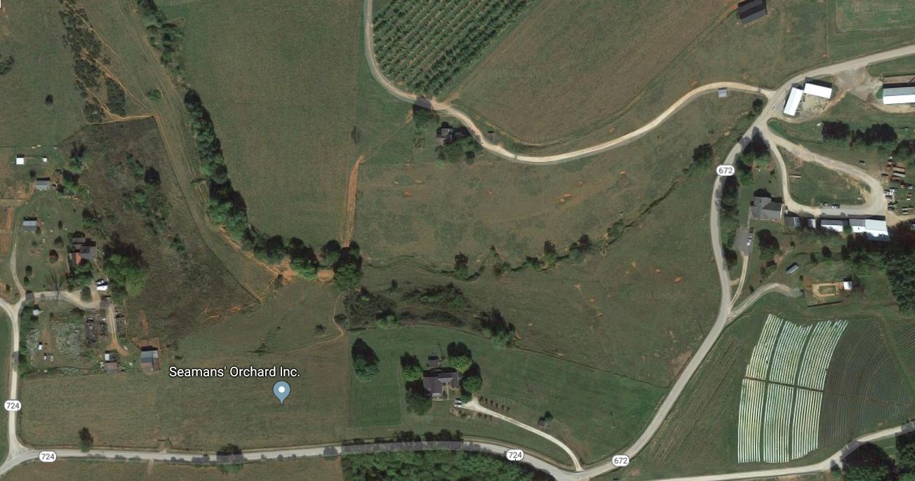
DESCRIBED BY COAST AND GEODETIC SURVEY 1935
0.9 MI E FROM LANES FORD.
0.9 MILE EAST ALONG COUNTY ROAD 655 FROM LANES FORD, NELSON
COUNTY, 0.4 MILE WEST OF THE JUNCTION OF COUNTY ROAD 672, 0.1
MILE WEST OF A BRIDGE OVER A CREEK, AT THE NORTH BANK OF A CREEK
PARALLEL WITH THE ROAD, 175 FEET SOUTHWEST OF A LARGE 2-STORY
WHITE FRAME HOUSE AT THE TOP OF A HILL, AND 46 FEET SOUTHWEST OF
THE CENTERLINE OF THE ROAD. A STANDARD DISK SET IN THE TOP OF
A CONCRETE POST. NOTE– THE MARK WAS RECENTLY UNCOVERED OF BRUSH.
Who Would’ve Thought…?
The region described above is apparently in the neighborhood of Seaman’s Orchard, with the creek being Hat Creek. Some of the features of the county were changed some by Hurricane Camille when it struck Nelson County so severely in August of 1969.
Well, after reading of all this, I had to wonder, “Who would have thought something so seemingly inconsequential would have proven to be so intricate and so fascinating?
Do you agree?
Note: You might also enjoy Analysis of an FBI Training Film on Physical Evidence
References:
- NOAA – National Geodetic Survey: Milestones of the Survey
- NOAA: Finding Survey Marks and Data Sheets
I have found a loose bench mark in a wash out. Is there a way to report it?
You might try https://oceanservice.noaa.gov/contact.html